How we capture site topography with drone-mounted LiDAR to produce survey-grade accurate deliverables for clients.
Overview
We use drone-mounted LiDAR to rapidly and accurately capture the topography of a site, generating the data needed for early estimating and for final, stamped survey deliverables. Compared to traditional ground survey alone, this approach covers large or difficult-to-access parcels quickly, penetrates foliage to reach ground elevations, and produces a 3D dataset of the site.
Workflow
- Flight planning & ground control: Survey-grade ground control points (GCPs) are established/provided to tie the LiDAR data to accurate real-world coordinates.
- LiDAR drone flight: The drone flies the parcel boundary/scope area, scanning the terrain and existing site features.
- Data processing: Point cloud data is filtered to remove foliage/vegetation, producing an accurate Ground Level Digital Terrain Model (DTM).
- Deliverable generation: Contour maps, Civil 3D surfaces, and point cloud exports are produced, with boundary or satellite imagery overlays as needed.
Deliverables Provided to Clients
- Contour map (with elevation tags on request), in PDF and DWG format
- Civil 3D surface and boundary/satellite imagery overlays
- Registered Licensed Surveyor seal on the stamped topographic survey
- Raw point cloud and DTM point cloud, in LAS, RCP, e57, and/or XYZ formats
Why It Matters for Estimating
Fast, accurate topographic data lets estimating teams model grading, drainage, and site work earlier and with greater confidence, reducing reliance on assumptions and change orders later in a project. The same dataset then carries forward as the survey-of-record deliverable for design and construction.
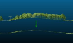
How we go from raw LiDAR to ground level, filtering foliage, land features, and man-made structures.
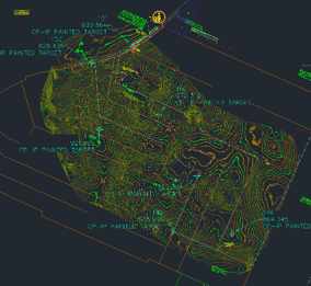
From our data, we create contour maps and surfaces that can be used for AEC teams